


MEET LAKE MURRAY

Click on the YouTube Link
Some info borrowed from Greater Lake Murray Country
The lake was named after William S. Murray, the engineer who was hired by Lexington Water Power Company (now known as Dominion) built the dam in order to generate electricity for Columbia. The lake and dam were under construction from 1927 through 1930.
Approximately 100,000 acres of land were purchased from families all over the area that would become the Lake. Landowners were paid between $15 and $45 an acre.
As part of the purchase, nearly a dozen communities had to abandoned, including Derrick, Pine Ridge, Selwood, Wessinger, Cantsville, Leaphart, Savilla, Boyleston, Lorena, Holly’s Ferry and Lorick’s Ferry.
Six schools, three churches and about 193 graveyards
containing 2,323 graves had to be moved. Some
families chose not to move the graves, and at several
area churches, there are monuments with these names
listed.
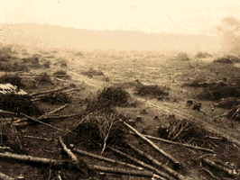
Clearing the land was no small task, and 2,000 men, who were paid $.50 a day, cleared 65,000 acres by hand using crosscut saws and axes. Out of the trees cut down, 100 million board feet of lumber was manufactured. Some of the lumber was used in the construction of the dam, and some were used to build a three-mile railroad between the dam site and what is known today as Irmo.
Each of the towers is 223 feet tall. The four smaller ones were built 16 feet in diameter to draw water from the bottom of the lake into the penstocks (a channel or pipe used to control water flow or supply water to something such as a hydroelectric plant). The penstocks deliver water from the base of the towers in the lake to the turbines in the power plant 1,150 feet away. Water enters the turbines through a spiral case of tapered tubes that diverts water through the turbines. Wickets (or gates) regulate the amount of water that enters. The largest tower is 60 feet in diameter and feeds water to the massive arch conduit beneath it.
At a cost of $20 million, the dam was built in three sections. It is 1 ½ Miles long, 375 feet thick, 208 feet high and covers 99 acres. The four spill gates, each 37 ½ ft. long by 25 feet wide are on the Lexington end of the dam. Between 1943 and 1946, two additional gates were added to the spillway, and the dam was strengthened by raising the crest 3 ft. The spillways were constructed to handle any flood situation where the lake’s level rose above the 360’ mark.
On August 31, 1929, the reservoir began filling with water. Lake Murray covers approximately 50,000 acres of land and 650 miles of shoreline. It is 41 miles long and 14 miles wide at its widest point.
On Dec 1, 1930, at 7 a.m. the first electric power-- -10,000 kilowatts---was delivered and Lake Murray was celebrated as the world’s largest power reservoir.
The official name of the dam is Dreher Shoals, although most people refer to it as Lake Murray Dam.
What is under the lake has been the fascination of many people. There are graves, the Wyse Ferry Bridge, a pipeline, several railroad tank cars, an old rock house, a church, also homes, boats, and bomb fragments under the waters of Lake Murray.
In the early 1940s, the U. S. military use the lake to train bomber pilots on the B-25 bomber airplanes. Seven of the lake’s islands, Bomb, Shull, Wessinger, Dreher, Spence, Mistey, and Holley Key were used as practice.
Lake Murray Boat Tour Company is here to provide amazing experiences on, around, and in Lake Murray, SC.


LINKS AND PARTNERS
Although the Lake takes up a lot of real estate, folks who live and work on and around the lake are a pretty close knit family. Here are some links you might find helpful to other services, restaurants, and experiences you can find on or nearly on Lake Murray


LAKE MURRAY WEATHER